Category Archives: Blog 5

St Michael

Above-ground water lines, surrounded by protective structures, run to houses in St Michael, Alaska.

The village of St. Michael is one of many places in Alaska that was born as a result of settlement by the Russian-American Company. The RAC, whose primary goal was to find fur-bearing animals and other valuable natural resources, sought to exploit the raw materials in Alaska. Their chain of settlements were made in an attempt to develop an empire that stretched along the West Coast of the American continent, from Alaska to Mexico. Before Russian incursion, St Michaels had functioned as a trading point for Yup’ik and Inupiaq peoples as it was positioned near where the borders of the two people’s lands begin to blur. In 1833, the RAC established a trading post called Redoubt St. Michaels on the small, shoreline-adjacent island in the Bering Sea that the Russians also named after the archangel Michael, forever changing the history and human geography of the area.

Location

St. Michael’s location on the Norton Sound means it is exposed to the hazards caused by weather as the harsh tides of the Bering Sea batter the coastline. A little over 9 miles long by 6 miles wide, the island of St Michael also houses the village of Stebbins; in total, there are just under a thousand people residing on the island. Although it is very close to land, it is disconnected from the mainland by meandering rivers and waterways. Because it is an island community, it is less feasible for residents to move away from the island’s dangers than their counterparts in mainland villages threatened by erosion such as Kivalina and Shishmaref.


Hazards

Islands are particularly vulnerable to hazards because they are surrounded by tempestuous waters. Due to the seismicity of the area (there is evidence of volcanic activity in the immediate area) high waves and tsunamis as a concern for St. Michael’s houses, built at just 26 feet above sea level. Underwater or terrestrial earthquakes could also cause damage from shaking. But the greatest threat to St. Michael is climate change in the form of global temperature rise, which results in the melting of permafrost. The entire island of St Michael is subject to damage from permafrost melt. Currently, efforts are being made to reinforce existing buildings and to build new structures that are better equipped to handle changes in soil. Temperature rise will also increase localized flooding, and erosion will also occur as the permafrost continues to melt, causing even more damage.


Climate

Temperature in St. Michael varies greatly throughout the year, peaking in the summer in the 60s and with extreme winter lows in the -20s. Mostly dry winters are followed by summer days when daily precipitation totals can reach 2.5 inches, and no matter the time of year, the weather is usually overcast and gray. It is further disconnected from the next closest large town of Nome in that it is not on the road system, however it can be accessed by boat when the water is free of ice. 


Boom
St. Michael was founded at the peak of the sea fur boom, when Russian promyshlenniki took the hides of seals, otters and other small furbearers from the Alaskan waters. It functioned as a trade outpost for the Russians, but was not densely populated until long after they had gone. At the start of the Klondike gold rush at the turn of the 20th century, miners and prospectors flocked to the Yukon River. Fort St Michael was established as a United States installation, placing forces close by in case action was needed in the Klondike. The subsequent gold rush in nearby Nome further increased activity in St. Michael, swelling its population to 10,000. The fort was deactivated in the 1920s, and the population returned to being mostly Yup’ik. Due to the island’s lack of a deepwater port, it has not seen as much activity in commercial fishing as other communities on the Bering Sea. This has also prevented it from becoming a part of the oil and gas supply chain until recently, when an oil company opened a small terminal and retail operation in the city. As both typically rely on petroleum fuels, Stebbins and St. Michael are in the process of installing renewable energy producing products: solar panel arrays, as well as a field of wind turbines.


Transportation & Tourism

Currently only one regional air carrier serves the St Michael airport, with service to Stebbins and Unalakleet where one may access a connection to Anchorage. The airport runway is not long enough to support large jets that may bring loads of passengers, and there is little in the way of attractions for tourists (unless they are the sort who see novelty in a traditional subsistence lifestyle). 

Perhaps the most important thing that St. Michaels has to offer those who do not call it home is the information about how communities deal with permafrost melt, as this community is in the throes of it. How they work together to repair damage and prevent further damage from occurring, as well as how they adapt to the environmental changes around them, can function as a case study for other Alaskan and Arctic communities. 

Blog 5

Angoon, AK

Throughout Alaska’s vast land lies a small city on Admiralty Island named Angoon, which is also known as the “Fortress of Brown Bears”. The only permanent settlement on the island, just south of Juneau, has a declining population of 523 people. Although it has a low population, it has the densest population record for brown bears and eagles throughout the entire state. This community is based on the rich Native Tlinglit culture that has seeped Alaska’s roots for decades relying on the commercial fishing and subsistence lifestyle. Given this, the area is surrounded by the pure nature of the Tongass National Forest, which is proclaimed to remain as an undeveloped wildlife sanctuary home to many tree and wildlife species. None the less, the Tongass National Forest is the largest national forest in the United States, and is also one of the biggest tools used in confronting climate change. 

On the spectrum, the community is much smaller than the wildlife ratio. Among the families, there are less than 20 homes where they paint indigenous tribal art for everyone to see. Upon using natural resources, water is scarce sometimes as well, as their water is provided by the Tillinghast Lake reservoir. Luckily, most of their homes have complete plumbing, so the water treatment plant is able to pipe water through the community. As demand for many goods and services are very low, they only have access to one general store, but no restaurants or shops other than that one store. Education is low, as well transportation. When it comes to transportation, most families own one car per household, and since the area is so small, the majority of people living in Angoon walk to their destination. In retrospect, the average employee in Angoon has three times less of a commute than the average employee in the United States. As quoted on the Law Earth Center, they state, “The median property value in Angoon, AK is $140,000, and the homeownership rate is 57.4%. Most people in Angoon, AK commute by walked, and the average commute time is 8.38 minutes. The average car ownership in Angoon, AK is 1 car per household.” There is only one way to get to Angoon, which is by boat or plane, in which Alaska offers a floatplane daily that travels between Juneau and Angoon. Due to this, there is very limited supply of goods, including food. Since Angoon is sometimes a desired place for tourists, they are advised to stock up on goods before leaving Juneau. 

In comparison to other southern islands in Alaska, Angoon receives far less precipitation levels than the rest. When Angoon became settled, Native Tlinglit took the lower rain levels to their advantage as fur trade was their main drive in the economy throughout the 1800’s until mid 1900’s. Once this trade began to fade, Angoon relied on the fishing industry for their economy and own subsistence. The climate in Angoon is described by having cool summers (ranging from 45-61 degrees) and mild winters (ranging from 25-39 degrees). The winters have had records in the past with very strong winds causing rough seas that affect the settlement. Because Angoon’s economy is based on the coastal water, there are many variables that are taken into place. Naturally, seafood production and consumption have increased significantly.

The economy of Angoon employs a total of 292 people in industries such as manufacturing, mining & oil & gas extraction, along with fishing and hunting. Although, this aspect is being hit hard by mining companies elsewhere. The Green Creaks Mining Company has encroached the land of the Hawks Inlet, infesting it by dumping their waste in the water. This has raised the issue of health concerns in the seafood. Dangerous minerals are leaked into the water, putting a huge risk to marine life and those who live off of the coastal waters. Of course this mine is essential to most of Alaska’s economy, but it is directly impacting Angoons sea life, and those who are ingesting the seafood with extremely high levels of bad minerals like mercury. 

Yet, the biggest question concerning Angoon is what is being done about the excess mineral waste flowing in the water. As the mines have been requested to clean up their messes, instead they paid the fines issued to them and ignored the requests. Due to this, Alaska Natives have come together to create The Angoon Community Association and put a stop to this before they reap the drastic measures this could create for the future. The Native tribes deserve the land and feel comfortable fishing for their own food as well as selling it. All in all, Angoon has been self reliant for years. Now that the fishing industry is so large and in demand, they need to address this issue at hand as this could collapse their economy. In the best efforts, Law Earth for Angoon describes this fight, “the people of indigenous demand retribution for not only themselves, but the land that has been abused, ask for representation in future projects relating to their territory or resource, and have the right to their traditional culture”.

Blog 5

Angoon is located in the southeast of Alaska. To Angoon’s northeast 55 miles is Juneau and to their southwest 41 miles is Sitka. Angoon is on Admiralty Island, with the Gulf of Alaska on the western shore and the Kootznahoo Inlet on the eastern shore. The land area is 22.5 square miles with 16.1 square miles of water. Angoon is part of the southeast climate zone. Here they experience cool summers, more mild winters, and heavy precipitation, though Angoon tends to experience a little less rain than most other areas. The temperature low for Angoon is -6 degrees Fahrenheit and the high is 77 degrees Fahrenheit. Because Angoon experiences warmer climate than most other parts of Alaska, there is rarely permafrost as it only occurs sporadically throughout the southeast. This settlement is a hypermaritime forest in the middle of the Tongass National Forest in a temperate coastal ecoregion.   In the winters, Angoon gets heavy northern winds, which create rough waters and hazardous landing circumstances for aircrafts.


Blog 5B

The indigenous people of this area are the Kootznahoo Tlingit who has been there for over 1,000 years. Angoon is a sustenance fishing community. Fishing and fish processing are the main industry in Angoon. Tourism is another industry here, though there is only one hotel with 8 rooms. The national forest is home to 1,600 brown bears, one of the densest brown bear populations in the world, and offers many fishing locations throughout Angoon. Angoon is only accessible by ferry or floatplane. Their electricity comes from a diesel generator, though they have been looking into non-diesel sources to cut down on electricity costs for residents. Angoon Oil and Gas sell gas at $4.55/gal and heating fuel for $4.34/gal. Angoon’s primary water source is surface water.

Blog 5: Russian Mission

Russian Mission is a town located in southwest Alaska on the west bank of the Yukon river in the Yukon-Kuskokwinn river delta. The river delta gives way to many lakes, marshes, streams, and wetlands, which provide an ample ecosystem for the animals that inhabit the surrounding boreal forrests within the subartic tundra ecoregion. Like much of Alaska, the climate can be characterized as one that endures long cold winters and short warm summers.

The town is composed of 5.7 square miles of land and .5 square miles of water and the survival of its inhabitants relies primarily on subsistence living, as it has been for over a hundred years. Just to give some background, the town rose to prominence in 1837 as the 1st Russian American fur trading post. By 1857 the subsistence based town and trading post drew in more outsiders, which brought greater cultural influences to its native peoples; the most important of   which was the Russian Orthodox church who established a mission there. By 1900 the area was formally named Russian Mission.

Today, the village is composed of 312 occupants. Most of the native and mixed population are of Yup’ik decent, while a fraction of it’s population is white. Being primarily Alaskan native, many of the inhabitants continue to practice subsistence living techniques such as hunting, fishing, and trapping which prove critical to maintaining their way of life there. While fishing appears to be their primary source of food (and income for seasonal workers), residents also rely heavily on hunting moose, black bears, small game animals (rabbits and porcupines), as well as waterfowl. Without these resources, their way of life would be next to impossible. While the village has grown over the years and has become more modern, the poverty rate still remains at 40% or higher with high unemployment, where overcrowding of homes remains a large problem. What is interesting is that most of the population is composed of young families ranging from birth to age 55; which means that once people become older and have more trouble maintaining this way of life, they move–possibly to Bethel (the closest village nearby) or to Anchorage. According to DCRA Information Portal this movement is likely a result of the city’s deteriorating infrastructure primarily in healthcare and transportation.

Being part of the subarctic tundra and subarctic coastal plains the land in Russian Mission is primarily composed of permafrost with very little viable soil as silt deposits often ruin the nutrient quality of the soil. In many areas of Alaska the permafrost gives way to a variety of problems as it hinders drainage and effects the structures established on top of it. According to the 2013 Hazard Mitigation plan the biggest natural treats to the area are flooding, erosion, and severe weather. In the region high winds, surface runoff (caused by severe weather), and ice flows contribute to erosion. While this keeps seasonal construction workers employed, it continues to hinder the repair and updating of important buildings that prove essential to the town’s being. This is an area that state and government funding continue to put copious amounts of money into in order to preserve the town. Why they do this I do not fully understand…since the 1940’s the town has had three major floods due to severe weather, snow melt, and ice flows during breakup season. This doesn’t take into account the ‘minor flooding’ that prompted various states of emergencies declared by the state’s governor over the years. From an economic standpoint the only real reason why I can see why this city continues to receive funding is to probably to keep ties with the Russian Mission Corporation, the Russian Mission Native Corporation, and the Russian Orthodox Church salient and satisfied.


Hello, Huslia!

Ts’aateyhdenaade kk’onh Denh, or Huslia as known in English, is a quaint village. It is located on the same latitude as Wales, the westernmost city in Alaska, and on the same longitude as Utqiagvik, the northernmost city in the U.S. Huslia spans just under twenty square miles and is home to just under 300 people. This village is sheltered by the brooks range on its northern side. This community is able to source water from the Huntington Slough, a small river. The 300 citizens of this community are amongst the most isolated in the entire world, as there are no communities in a roughly 100 mile radius of Huslia. As per coastal plains, Huslia is part of the Yukon Intermontane Plateau Taiga, within the Koyukuk Flats. As part of the Intermontane Basins and Plateaus, it has extensive physiographic features.  

Compared to most of Alaska, Huslia is surprisingly warm for a settlement in the interior climate region. Being in the central interior, its yearly average temperatures range from -13F to 69F. This wide temperature range can largely be attributed to the lack of any bif body of water which may act as temperature moderator. Settlements on the coast tend to have warmer winters, and colder summers, as the water dulls down the extreme temperatures.  

Huslia is on the Koyukuk River, which means it faces the natural hazard that has been detrimental to most rural communities. Erosion is like a siren song. It seems logical to build a community on an elusive river, as running water is the foundation of life. However, running water is also the source of land erosion. The rivers are eroding the communities that were built on them. While water can provide the basics for life, it can also take away others, such as a safe shelter.


Huslia’s economy is a difficult one. The unemployment rate in the village is roughly five times higher than the national average. Over half of the village’s occupants make a living from public administration or through construction. Despite these challenges, it’s future looks bright. The local school has recently undergone a $17 million renovation. Further, it has implemented a new biomass system which allows the community to produce its own energy, steering away from a reliance on expensive imported diesel.  

Culturally, Huslia is invested in dog mushing. Many dog mushing icons have been born and raised in this village. Huslia, like many Alaskan villages, places a cultural importance on mushing. Furthermore, many in the village hunt for their own food. This culture of self sustainability is noticeable, both on an individual level, and on a village wide level. If there is anybody that can thrive in the harsh conditions of Alaska, it will be the Huslians.

Blog 5

Settlement Study: Tyonek, Alaska

By Catharina Laan

Spring Semester 2020

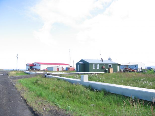
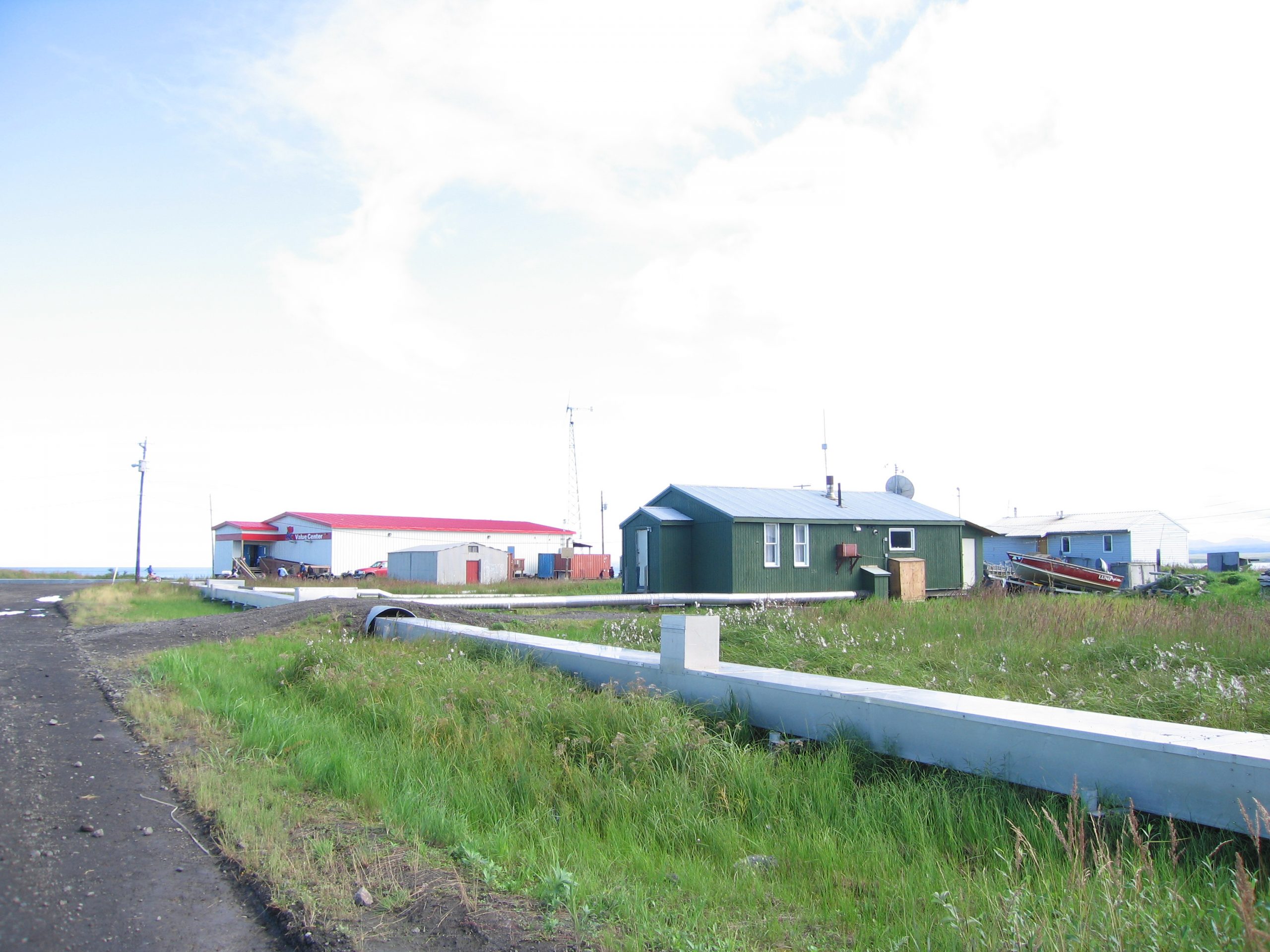
Tyonek is a coastal city, located in south central coastal city of Alaska. It is a small settlement of native Alaskans. Specifically, it is located on the northwest shore of Cook Inlet, 45 miles southwest of Anchorage. The people of Tyonek are part of Athabascan region and have the dialect called Dena’ina.  It is the only community in the Kenai Peninsula Borough that is not located directly on the Kenai Peninsula. It lies at approximately at approximately 61 ° 04′ N Latitude, 151 ° 08′ W Longitude. The village, encompassing 22 square miles of land and 3 square miles of water.

Today there are about 190 residents in Tyonek; however, the Tyonek Native Corporation (TNC) has over 800 shareholders that can practice subsistence hunting, fishing, and gathering within the District. The community has one school that currently educates about 35 students in grades K-12. The Tyonek community is accessible by plane or boat, but is not connected by road to Anchorage.

In describing the physical geography of Tyonek, there are many aspects to address this. The physiography, climate, state whether it has any permafrost, ecoregion, and natural hazards will be described.

First thing to describe in this settlement its physiography which is located in the Pacific Mountains and Valleys Region.

Second, is to describe the climate of Tyonek which is located in the South Central region and within that there is variation due to the location of its latitude, maritime, continental land influences. Climate is generally mild for the region, with average winter temperatures ranging from 4 ° to 22 ° F and average summer temperatures ranging from 46 ° to 65 ° F. Temperature extremes have been recorded from -27 ° to 91 ° F. The average annual precipitation is 23 inches, including 82 inches of snow. It generally has moderate precipitation and mild winters.

Tyonek is generally free of permafrost.

The type of ecoregion that Tyonek is located in is on the first level is Temperate Continental, on the  2nd level it is Coast Mountains Boreal, and finally, on the third level of the ecoregion it is Cook Inlet Basin-Susitna Lowland.

The natural hazards in Tyonek are fires, flooding, earthquakes, tsunamis, and volcanoes eruptions. In the 1930’s where the original village existed at that time, there was a big flood, so the village had to move to higher ground. So, they moved 7 miles northeast to a new site, on bluff, and the town is still called “Tyonek’.

In the case of earthquakes, in the last 60 years, there was a big earthquake and it occurred on March 27, 1964, magnitude of   9.2 with epicenter in the Prince William Sound region of Alaska. This 1964 Alaskan earthquake, also known as the Great Alaskan earthquake and Good Friday earthquake, its affects went across south central Alaska. This earthquake caused ground fissures, collapsing structures, and tsunamis, resulting about 131 deaths. It lasted four minutes and thirty-eight seconds and it remains the most powerful earthquake recorded in North American history, and the second most powerful earthquake recorded in world history. Tyonek only suffered minor damage due to it being far away from the epicenter. The latest set of earthquakes near Tyonek was an earthquake on Feb 23, 2020, where it was a magnitude was 3.5 earthquake that hit at 7:15 a.m. and was centered in a spot that was 9 miles (15 km) southwest of Tyonek. On March 30, 2020, another earthquake with its epicenter location was 5 miles northeast of Tyonek, with a magnitude of 1.5 strength.

In regards to volcanoes, about 68 miles west of Tyonek is a volcano named Mount Redoubt. It has erupted four times since the 1900’s: 1902, 1966, 1989 and 2009, with two questionable eruptions in 1881 and 1933. The eruption in 1989 spewed volcanic ash  to a height of 45,000  ft (14,000  m).

A big fire occurred on May 2014 in Tyonek that affected their 1800 acres of their land. The residents had to be evacuated of the area.

With all these natural hazards of fires, floods, earthquakes, volcanoes, one must really want to live here and put up with these constant life changing events. The Alaskan natives have been here for over 1800 years for many reasons: the beauty of the land, traditions and heritage of the people have their own space, and surviving on the subsistence living. These Alaskan natives have decided to put up natural hazards as part of life: home sweet home.

Second part of this study of the settlement regarding Tyonek is the human geography. Dena’ina Athabascans arrived in the Cook Inlet region between 500 and 1000 AD. In pre-contact times, it is estimated that 4,000-5,000 people were living in West Cook Inlet within the Tyonek Tribal Conservation District boundaries.

Records show that for the past 1000 years, the people of and from Tyonek embrace a culture rich in the long-held traditions, have their own song, dance, storytelling, and religion. “Tebughna,’ which translates as “the Beach People,’ is the name for the people from Tyonek.   They lived a subsistence lifestyle (and many still do), relying on the rich natural resources of the Cook Inlet. Hunting, trapping, fishing, and whaling have always sustained the people of Tyonek.

Tyonek first appeared on the 1880 U.S. Census as the unincorporated   “Toyonok Station and Village”. It featured 117 residents, including 109 Tinneh, 6 Creole (Mixed Russian & Native) and 2 Whites.

At the 2000 Census there were 134 housing units at an average density of 2.0/square miles. The racial makeup: 4.66% White,   95.34%  Native American, and 2.59% of the population were  Hispanic  or  Latino  or any race. As of the census  of 2000, there were 193 people, 66 households, and 45 families residing. The population density was 2.9 people per square mile (1.1/km ²). The median income for a household was $26,667, and the median income for a family was $29,792. Males had a median income of $26,250 versus $26,250 for females. About 2.1% of families and 13.9% of the population were below the  poverty line. Saint Nicholas Orthodox Church which can be traced its origins to 1891, serves the majority of the village’s residents.

The first recorded encounter between the Dena’ina and the Europeans occurred in May of 1778, when the British naval ships, The Resolution and The Discovery, under the command of the famed Captain James Cook, anchored off West Foreland, near the Dena’ina Villages of Qezdeghnen (Kustatan) and Tubughnenq’ (Tyonek).

In 1794, Captain Joseph Whidley, a Vancouver Expedition, visited Tyonek and found that a Russian fur trade company, the  Lebedev-Lastochkin Company, maintained a small trapping station on the site of Tyonek with a residence of nineteen Russians.

Between 1836 and 1840, half of the region’s natives died from a smallpox epidemic.

The Alaska Commercial Company had a major outpost in Tyonek by 1875.

Upon the discovery of gold at Resurrection Creek in the 1880s, Tyonek became a major hub for goods and people seeking to make their fortunes in Alaska.

A saltery was established in 1896 at the mouth of the Chuitna River north of Tyonek.

The devastating influenza epidemic of 1918-1919 left few survivors among the Athabascans.

In the 1950s and 1960s, oil and gas companies began exploring the Cook Inlet region, and when gas deposits were found, then several gas companies moved into the area. In 1965, the federal court ruled that the Bureau of Indian Affairs (BIA) had no right to lease Tyonek lands for oil development without permission of the Indians themselves. Later, oil companies paid $12,942,972.04 to the Natives of Tyonek for the lease of Tyonek lands in order to drill for oil and gas beneath the land. With this money, the people of Tyonek built new housing for their people of Tyonek, a school for the youth, and a new Tribal Center. Also, made improvement of roads, and expanded airstrip.  Their school named Tebughna (“beach people’) School and it is home to 35 students, ranging from Kindergarten to the 12th grade. They have 2 teachers for one middle/high school teacher, one elementary teacher, and a principal/teacher.

In 1968, the leaders of Tyonek’s supported and helped fund the Alaska Federation of Natives who spearheaded the passage of the Alaska Native Claims Settlement Act (ANCSA) in 1971.  In 1973 and under the agreements set forth under ANCSA, Tyonek formed Tyonek Native Corporation and it then became a federally recognized Alaska Native Corporation.  While starting out small, the Corporation has since branched out to create and include many successful subsidiaries and businesses.

From the 1970s to the early 2000s, there was sporadic commercial logging occurred on the lands surrounding Tyonek. Extensive road building has occurred to facilitate the logging of trees and access to drilling sites.

Current power requirements can be met by the Beluga Power Plant in Beluga, Alaska, just northeast of Tyonek. Operated by the Anchorage, Alaska-based Chugach Electric Association. Chugach has a total of five combustion turbines in Alaska and is the primary supplier of electricity in the state, with over 2,000 miles of transmission and distribution lines. The Beluga Power Plant is not only the largest Chugach plant; it is also the largest power plant in Alaska, generating 385MW. The plant is accessible only by barge or aircraft, as no roadways connect to any part of Alaska’s major highway system. Beluga is currently fueled by natural gas, although other more economic and environmentally friendly options are being explored, with an implementation goal around the year 2020.

Tyonek Native Corporation is currently seeking to develop its sand and gravel resource for export to global markets. The North Foreland Facility, is the only all-season, deep-water cargo port. This facility was deemed by many Asian and U.S. firms and governments as one of Alaska’s most cost effective commodity port sites. Built in 1947, this steel and pile supported structure is 1,475 feet long, 17 feet wide, and provides a berthing face of 685 feet. A 174 by 50 feet wharf is also located at the end of the pier. This port not only has the relatively stable climate, including moderate precipitation and mild winters, but also from the deep pier depths; therefore it is subject to less ice than many other locations in Alaska.With its mostly ice-free location on the west shores of the Cook Inlet and large mineable sand and gravel resources, immediately adjacent to the Tyonek Pier, a Tyonek operation offers a unique set of logistics to supply high- quality concrete aggregate supplies to the West Coast and Far East markets. Being already halfway to the Far East markets on the Great Circle shipping routes, there could be opportunities to get back-haul shipping rates on vessels returning empty to Asia. With growing population pressures there is steadily increasing demand to build new infrastructure in the Pacific Rim Nations.

The rapid development that occurred in Tyonek during the 1900s, as well as the history of Russians and Euro-Americans from the past three centuries, and the epidemics that caused major lost oof the Native Alaskan who lived in this area, it has most finitely left an impact on the community of Tyonek and the natural resources in the region.

In the early 2000s, leaders in Tyonek began looking for ways to take a greater role in determining their own natural resource future. With about 190 residents still residing in Tyonek and with the Tyonek Native Corporation having  over 800 shareholders that can still practice subsistence hunting, fishing, and gathering within the Tyonek area, their hope is to preserve the culture, traditions, and subsistence practices. Subsistence, or the use of fish, wildlife, and plants for home use, is vital for the community of Tyonek to maintain for generations to come in the future. The strong connection between the people of Tyonek and the land and its resources is intertwined with its culture and history and they seek it to maintain forever.

Blog 5: Hooper Bay

   Hooper Bay is a city in southwest Alaska. It is located on the coast of the Bering Sea and the north coast of a bay called Hooper Bay. The city is also in the Yukon Delta National Wildlife Refuge. The City of Hooper Bay is located in the Yukon-Kuskokwim Delta approximately 80 miles south of the mouth of the Yukon River.  

   The elevation of Hooper Bay is 43 feet above sea level. The land around Hooper Bay is tundra so there are no trees. There is a large, continuous layer of permafrost under Hooper Bay and the surrounding area.  

   Hooper Bay is vulnerable to several natural hazards including flooding, severe weather, earthquakes and wildfires. The coastal land around Hooper Bay is also eroding. Community leaders report that the climate is warming and this is causing the permafrost to melt and has resulted in increased flooding and erosion. Like Shishmaref, the people of Hooper Bay are discussing the possibility of moving the village to higher ground if a reliable water source can be found nearby.

   Hooper Bay has a Continental Subarctic Climate under the Köppen Climate Classification system. It has cold winters but not as cold as the interior. The record low temperature in Hooper Bay is -26.0 °F. Summers are cool as well. Only the months of June and July have an average high over 50 °F. On average, Hooper Bay gets 25.5 inches of rain and 68.2 inches of snow each year.  

   The City of Hooper Bay was incorporated in 1966. It is part of the Unorganized Borough, in the Kusilvak Census Area. The population of Hooper Bay is 1247 people. Hooper Bay is approximately 92% Alaska Native and 4% White. Hooper Bay was included in the Alaska Native Claims Settlement Act (ANCSA), and is recognized by the Federal Government as a Native village. The Yupik community name for Hooper Bay is Naparyaarmiut.  

   The economy of Hooper Bay revolves around public spending, commercial halibut fishing and subsistence activities. Coastal Villages Seafoods operates a halibut processing facility in Hooper Bay. However, despite the importance of commercial halibut fishing, relatively few of the residents of Hooper Bay work in the fishing industry.  

   Many people in Hooper Bay have public service jobs or work in the service industry. For most of the people of Hooper Bay, wage work is seasonal. Most people in Hooper Bay engage in subsistence activities such as hunting, fishing and gathering. Residents hunt walrus, beluga whales, and waterfowl and gather plants and berries. Subsistence fishing is also important in Hooper Bay. People subsistence fish for halibut and red salmon, pink salmon and chum salmon.  Some people also make grass baskets or ivory carvings to earn extra income.  

   Hooper Bay has high levels of poverty. In 2010, Hooper Bay had a per capita income of $8,635 and a median household income of $34,375. Hooper Bay ranks 219th out of 299 Alaskan communities in terms of household income.  

   Hooper Bay is not on the road system. It is only accessible by ship or by plane. The airport in Hooper Bay has a state-owned 3,300 foot long paved runway. Groceries are flown in year round. Residents of Hooper Bay primarily use ATVs and snow machines for transportation. Barges deliver shipments of fuel and supplies during the summer. Hooper Bay has one school for grades K-12.  

   Residents of Hooper Bay get their water from three wells that were drilled in 1997. Water is piped to the school, teacher housing, the clinic building, and a washateria. Besides teacher housing, none of the homes in Hooper Bay have indoor plumbing. People get water from the washateria and use buckets to haul waste to the local landfill. The community has a health clinic and in emergencies residents can be airlifted to the hospitals in Bethel and Nome.  

   The residents of Hooper Bay get electricity through a diesel generator that is operated by the Alaska Village Electric Cooperative (AVEC). Hooper also has three wind turbines, built by AVEC in 2004. The wind turbines provide 24% of the electricity used in Hooper Bay. Buildings in Hooper Bay are heated with heating fuel, which is delivered by Crowther.  

   There are no major mining operations near Hooper Bay. Nothing that I found mentioned a tourism industry in Hooper Bay and I don’t really see potential for Hooper Bay to become a major tourist center. I have been to Nome, which is much larger and I would not consider Nome to be a major tourist center either.  

   In the future, if climate change continues to cause increased erosion around Hooper Bay then the community may need to be relocated to higher ground. It is likely that this will occur if the permafrost continues to melt and sea levels rise due to climate change. I would not be surprised if the city has been moved twenty or thirty years from now.  

Sources:

Department of Commerce, Community, and Economic Development. 2020. “Hooper Bay, Alaska.’ Accessed April 10, 2020. https://dcced.maps.arcgis.com/apps/MapJournal/index.html?appid=0b0dbcafc57d4971b4daeb307c6eab15#

National Oceanic and Atmospheric Administration. 2011. “Fishing Communities of Alaska: Hooper Bay.’ Accessed April 10, 2020. https://archive.fisheries.noaa.gov/afsc/REFM/Socioeconomics/Projects/communityprofiles/Hooper_Bay_Profile_2000_2010.pdf


Blog 5a & 5b Nulato

Nulato is an Alaskan settlement located on the western bank of the Yukon River, some 35 miles downstream from Galena or 310 air miles due west from Fairbanks. See Figures 1 — 3 for a better perspective on Nulato’s location.

This location puts Nulato in the Intermonte Basins and Plateaus physiographic unit. As such the terrain here is rather gentle and mild. To the north of the town there are many small ridgelines at roughly 1500 ft MSL. These ridges are separated by broad flat valleys. To the south of town across the Yukon River, there is a large flat region pot marked with small lakes/ponds and soughs. After roughly 12 miles, the marshy flatlands gives way to hills roughly 2500 ft MSL tall. The forests here are lowland and upland spruce and hardwood; with lowland forests being found to the south and upland to the north. Nulato lies in the Bergina Boreal, Temperate Continental Ecoregion of Alaska.

The climate of Nulato is dominated by continental factors/controls; this means that its location far inland allows for the earth’s crust to heat up and cool off rapidly. As such it is in the interior climatic region. This means that Nulato has hot summers and cold winters; the hottest days of the summer here can be in the 90s and temperatures in the winter can be in the minus 60s. It should be noted that Nulato is rather close to the Bering Sea Coast climate region.

Permafrost is discontinuous around Nulato as such buildings and infrastructure can be more readily constructed and relied on once built. It should be noted that the soils in this area are very silty and as such frost susceptible and erosion prone if flooded.

Natural hazards surrounding Nulato are primarily floods and ice jams due to its location on the banks of the Yukon River. This is a historical problem for this town and reports of erosion have been made and where investigated by the U.S. Army Corps of Engineers in 2007. Their baseline assessment can be viewed here, https://www.poa.usace.army.mil/Portals/34/docs/civilworks/BEA/Nulato_Final%20Report.pdf.

As the link above shows, no known damage was found from periodic floods and ice jams so this implies that the problem is well managed and the locals are well prepared to mitigate risks and damages from floods

The resource economy of Nulato is sparse. Trade was always the main source of income and resources for Nulato. In fact, Nulato’s tribal council states that the settlement was founded as a trading town due to its strategic location for trade alone the Yukon River.  In the mid to late 1800s steamboat travel was high on the river and would stop twice daily at Nulato for firewood, supplies and passengers.  1884 saw a gold rush with most miners leaving for Fairbanks or Nome by the early 1900s. In modern times the economy of Nulato is dependent on government funded employment such as BLM emergency firefighting or other short-term projects. There is little to no tourism here, though there are several air services companies which fly into the local airport. A reported 55% to 78% of Nulato’s workforce is “perpetually unemployed’[1]. As such most Nulato’s residents live a subsistence lifestyle.

In summation, I do not see much change in the future for Nulato. Its well off the beaten path and not threated by existential problems like Shishmaref. What natural problems the town faces (floods and ice jams) it deals with regularly and effectively. With no real outside influence (aside from providing employment) and no known developable resources I see no factors to change Nulato in meaningful way for the foreseeable future.

[1] https://www.nulatotribe.net/home-2/self-governance/nulatos-history/

Shungnak

Shungnak is a city located in the Northwest Arctic Borough of Alaska. Situated 150 miles east of Kotzebue on the Kobuk River; Shungnak is dependent on barges and river traffic for many of it’s supplies during the summer.   The winter freezes of down to -60* render the river unnavigable for much of the year and only air travel connects the city to any sort of logistic supply.   The land is composed of permafrost rendering any construction more difficult and expensive.   Earthquakes have been known to occur but did not cause much damage within Shungnak.

Originally the community was founded further up river as a supply point for local mining operations.   Supplies would be brought in by barge from Kotzebue and distributed throughout the area via trails, barely improved roads, and at times sled dogs.   As the river shifted course the original site was no longer habitable in the same way and the community moved to a more stable location.   The old site is now the village of Kobuk, while the new community was called Kochuk.   Eventually however Kochuk reverted to being called Shungnak a derivation of the Inupiaq word for jade “Issingnak’.

Bering Air currently services Shungnak out of Kotzebue.   The current Corona Virus plaguing the world however has disrupted the air travel industry, both through quarantines and the failure of Raven air, rendering the city’s 256 inhabitants severely isolated.   Power and infrastructure all rely on diesel fuel imported this way and represent as significant danger of deprivation.   In the past conditions have pushed the price of fuel to over $8.00 a gallon.   The Ambler Mining District road would terminate North of Shungnak providing some connection to the Dalton Highway.   This road is proposed as a toll/ mining road that would not however be for general use.   In theory all goods not related to mining operations would still need to be barged up the river or flown in.

Shungnak currently derives it’s electric power from diesel generators.   This is problematic due to the cost of fuel and fragility of the supply chain.   Kotzebue is currently experimenting not far away with solar power and is set to install 1400 panels.   If successful building out to Shungnak would reduce maintenance costs for both and provide a level of independence.

Tourism has potential if Shungnak develops it’s economy.   There are only 4 registered businesses in the town and the sale of alcohol is prohibited.   If mining operations provide jobs and there is a way for the economy of Shungnak to interact with the industry in beneficial manner the town could see major growth if the access project is completed.   This could result in the facilities and businesses necessary to attract and maintain tourists looking for access to the wilds of Alaska.   Currently though it looks as if economic development hinges on the Ambler access road.


Blog 5: Teller

Teller Settlement


5a:  


Teller is a federally recognized tribe that as of 2018 has a population of 237. It is located in the Nome census area, 72 miles northwest of Nome itself. Teller sits on the southern half of a spit of land that separated Port Clarence Bay from Grantley Harbor. This is all located on the Seward Peninsula. The whole village is not on the spit, it expands pretty far inland. The village has a total area of 2.1 square miles.    

Teller’s climate is located in the transitional climate zone. This means that it is mostly tundra with some boreal forest. They experience long, cold winters and short, warm summers. Grantley harbor, part of Port Clarence Bay, is usually ice-free from early June to mid-October. It has an average snowfall of 46.2   inches per year, with 76 days out of the year having precipitation. The average high temperature is about 30 ºF, and the average low temperature is about 17 ºF. The highest recorded temperature is 82 ºF, and the coldest recorded temperature is -36 ºF.  

In recent years, the Nome-Taylor Highway has been ruined by permafrost. The airport in Nome has had patches of permafrost thaw on the runway, causing expensive repairs. Teller is located next to the water of Point Clarence Bay, and with the permafrost thawing, their bluffs are susceptible to erosion.  

 Warming temperatures have caused sea levels to rise, and since Teller is a coastal community, they have been greatly affected by erosion. Storms are also a side effect of this climate change, contributing to the continuing erosion. Birds and mammals have also died off because they couldn’t adapt to the changing climate. They have also experienced extensive flooding, and are considered at risk for flooding by the Government Accountability Office. Because of the flooding and erosion, I think that Teller will have similar issues as Shishmaref, and will eventually have to move to a new location or just farther inland.  


5b:  

The top three main forms of income that the residents of Teller have are public administration, health care and social assistance, and retail trade. Transportation and education are the next most popular forms of income. The average income per resident is about $10,000 per year, and the average income per household is about $26,000 per year. Both of these numbers are well below the national average. There has not been a recent economic boom, Teller’s unemployment rate is about 12%, and their job market rate has gone down by 0.5%. However, in the early 20th century, Teller had a large economic boom because it was a major trading center. The population was about 5,000 people compared to the 237 people in 2018. Tourism is essentially nonexistent in Teller. They have an airport, but there are no hotels or buildings aimed at tourism.  

Teller has an airport, which is mainly a landing strip. The airport is located pretty far away from Teller itself, you have to drive a few miles on the Nome-Teller Highway to get to the middle of the community. Teller consists of mainly residential buildings, and then there is the school and what seems to be a warehouse with several shipping containers surrounding it.  

Teller is a fishing community, and the residents fish from Salmon River, Pilgrim River, and Agiupuk River. They have several fish camps that they use during the summer, where they primarily catch red salmon. During the summer and winter, they fish for pike, and during the spring and fall, they fish for herring, whitefish, and tomcod. None of this fishing is for profit though, it is for subsistence. Nobody in Teller gains income by fishing, hunting or agriculture.  

For electricity, Teller uses a diesel generator, and fuel costs about $5.00 per gallon. Power is provided by the Alaska Village Electric Coop. Fuel is provided by the Teller Native Fuel Business. They receive their fuel by barge, and while there is no data on where the shipments come from, it can be assumed that they need to rely on shipments from larger communities like Nom. For water, they have a water treatment facility, but there is no data on what their primary source of water is or how many people have access to that water.