Marshall, Alaska is located in the west region of Alaska at latitude 61.8791 and longitude -162.087 (DCRA). This community is just outside of the Yukon-Delta National Refuge and near the lower end of the Yukon River and the Yukon-Kuskokwim Delta. The physiography of the area is within the Intermontane Basins and Plateaus regions. Temperatures are moderate in this region since Marshall is within the Bering Sea Coast climate region. This area receives about 16 inches a year of precipitation and the average temperature is 51 degrees (Lesson 5 Climate). This land is in an area of discontinuous permafrost and is considered a subarctic tundra. Looking further into the ecoregion, Marshall is located on the edge of the Nulato Hills (figure 6.16, Lesson 6) nested between Pilcher Mountain and Okumaik Mountain. Marshall has Bottomland and Coast Western Hemlock-Sitka Spruce trees (Figure 6.13, Lesson 6). The DCRA considers Marshall a transitional area of tundra and boreal forests. From examining the ecoregion map Marshall is on the border of the Lower-Yukon Delta and Nulato Hills. The Lower-Yukon Delta has a high amount of glacier sediment brought down through the river (Alaska Fish and Game). The community itself stretches a total of 4.7 square miles (DCRA).
Marshall, Alaska DCRA Community Photo Library
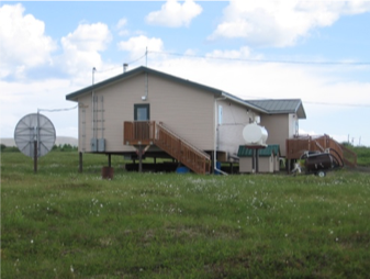
Marshall has a few potential natural disaster risks that could become hazardous within the region. The Yukon River has been the source of many dangerous floods within the state. The community is within the flood zone of the Yukon River and other creeks, the community is subjected to potential flooding caused by ice jams as well. Many of the homes and other community buildings are on stilts to prevent damage if flooding occurs. To the left is an image of the clinic from the DCRA photo library, notice how the foundation is on stilts. Land erosion over time is a potential hazard as well since the community is along the river.
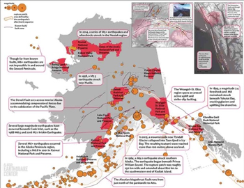
Marshall has several types of spruce trees within the transitional zone, this in particular makes forest fires another potential danger to the community. From the Alaska Wildfire page, many large forest fires have surrounded the community of Marshall in the past. Fortunately, none of the fires recorded by Alaska Wildfires have reached the community itself. By examining the Alaska Earthquake Center’s map (below), Marshall is not in a large density earthquake area. The town is significantly far away from the subduction zone and interior Alaska where most earthquakes appear. This area has a fairly low natural hazards risk.

Alaska Earthquake Center
The community of Marshall has had several names, one of them being Fortuna Landing. According to DCRA, the current population of Marshall is 437 and the community is considered an Alaska Native Claims Settlement Act Second Class City. It is within the Alaska Native Calista Corporation region and Kusilvak Census area. Approximately 97% of the community is Alaska Native, and the community is mostly Yup’ik. The community has a water plant, school, church, post office, clinic, and community hall. From looking at an area map from the community database, it seems that the community has built a new airport away from the river. The original airport was 2061.2 feet, whereas the new airport landing strip is 3903.4 feet in length. Other forms of transportation include boats in the summer, and the barge system. The city has electricity provided by a diesel generator (DCRA).
The first expedition to Marshall was in 1880 with a population of 120 people, and more than 30 years later gold was discovered (DCRA). From YukonAlaska.com, Marshall was the 25th known mining camp during the early 1900’s for both silver and gold. Most of the mining was placer mining from Wilson Creek.
By analyzing the Renewable Energy Atlas of Alaska, Marshall has oil within the area (see image to the right) but there is no documentation found about oil drilling near the community.
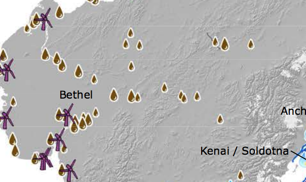
Renewable Energy Atlas of Alaska
The community has potential for river power and heat recovery as a renewable energy source (see image below).
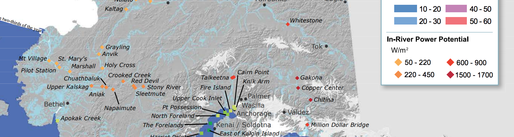
Renewable Energy Atlas of Alaska
River power could be a source of energy in the summer when the river is finally ice-free. Due to the area that it is in, solar power is not an optimal energy source. However, wind is a potential resource, but the area is limited. According to the DCRA, this community relies on subsistence and fishing. Many types of fish spawn in the Yukon including five types of salmon, Dolly Varden, and Arctic grayling (Alaska Department of Fish and Game).
Marshall has seen booms for fishing and mining, and is in a low hazardous region. Since there is oil near Marshall, there may be potential for oil drilling in the area. However, it may be challenging since the community relies on fishing and is located Native land. Since Marshall was once a goldmine community and it is on the Yukon, it could potentially see a small amount of tourism, if the Yukon becomes a popular tourist route.
Sources:
Renewable Energy Atlas: https://alaskarenewableenergy.org/wp-content/uploads/2016/07/RenewableEnergy-Atlas-of-Alaska-2016April.pdf
DCRA: https://www.commerce.alaska.gov/web/dcra/PlanningLandManagement.aspx
YukonAlaska.com
Alaska Earthquake Center
https://www.adfg.alaska.gov/static/species/wildlife_action_plan/section3b.pdf